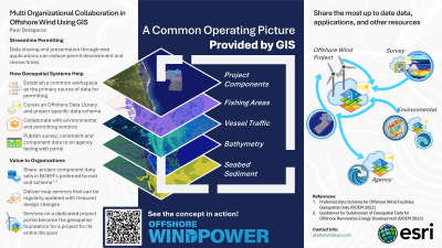
Presentation Description: Permitting an offshore wind facility is a long, data-centric process. This presentation will feature how Geographic Information Systems (GIS) is leveraged as a means to communicate data and information products between developers, environmental/permitting vendors, government agencies, and survey/installation vendors. Using GIS, these multiple stakeholder organizations are able to securely and seamlessly share project data in a dedicated enterprise GIS environment.
Using a single shared environment ensures accuracy by minimizing errors occurring in data transfers and hand-offs, streamlines communication across organizations, and maintains a system of record for all project data, including non-spatial data. A shared environment also ensures a uniform data schema which among other benefits, creates a common language across for the project resulting in better understanding across the different stakeholder organizations.

.png)
.png)
 photo")